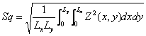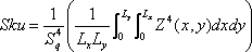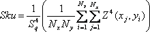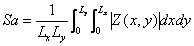
where Lx and Ly are the size of a definition area
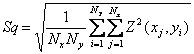
Digitized form :
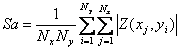
where Nx and Ny are number of data points in x and y direction.
where Lx and Ly are the size of a definition area
Digitized form :
where Nx and Ny are number of data points in x and y direction.
Root mean square of the ordinate value Z(x,y) within a definition area
AnaLytical Form:
where Lx and Ly are the size of a definition area
Digitized form :
where Nx and Ny are number of data points in x and y direction.
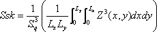
Skewness of the ordinate value Z(x,y) within a definition area
AnaLytical Form:
where Lx and Ly are the size of a definition area
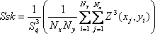
Digitized form :
where Nx and Ny are number of data points in x and y direction.
Kurtosis of the ordinate value Z(x,y) within a definition area
where Lx and Ly are the size of a definition area
Digitized form :
where Nx and Ny are number of data points in x and y direction.
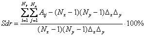
Root mean square slope of the ordinate value Z(x,y) within a definition area

where Lx and Ly are the size of a definition area
Digitized form :
where
Nx and Ny are number of data points in x and y direction.

where Lx and Ly are the size of a definition area
Digitized form :
where
Nx and Ny are number of data points in x and y direction.
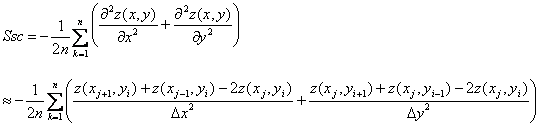
for any summit located atand n is a number of summits. Eight nearest neighbors are used to determine summits of areal topographic data.
References
1. Surface Texture (Surface Roughness, Waviness, and Lay), an American National Standard, ASME B46.1-2002, New York, NY
2. K. J. Stout, P. J. Sullivan, W. P. Dong, E. Mainsah, N. Lou, T. Mathia and H. Zahouani, The Development of Methods for The Characterisation of Roughness in Three Dimensions, Report EUR 15178 EN. EC Brussels, 1993
3. L. Blunt and X. Jiang, Advanced Techniques for Assessment Surface Topography, 1st edition, London Penton Press, 2003, ISBN 1903996112
4. ISO/TC 213 N057 2004 Draft ISO/WD Surface texture: Geometrical Product Specification (GPS) - Surface texture: Areal - Part 1: Terms, definitions and surface texture parameters (International Standard Organization)